AppBrain
|
Apps
Apps
Apps being viewed right now
Trending apps today
Most popular apps
All-time most downloaded apps
Top rated apps
Statistics
Docs
Developers
Sign up
Log in
Android Apps
>
Maps & Navigation
>
Paid
Category
Maps & Navigation
Sort by
Trending
Recent downloads
All-time downloads
Top rated
Popular in
Filter by
Off
Free
Paid
New
Updated
Price Reduced
No ads
Page 10 of the
popular Paid Maps & Navigation Apps for Android in Sweden
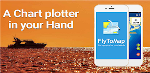
Wilson Lake Alabama GPS Charts – Click to show
Wilson Lake Alabama GPS Charts
FLYTOMAP INC
Flytomap is a valid and interesting alternative, Featured on the Deck Featured on Geomedia Worldwide Marine and Outdoor Maps available when connected, thanks to viewer.flytomap.com Worldwide Satellit…
$2.99
0.0
1+ downloads
|
Maps & Navigation
0.0
$2.99
FLYTOMAP INC
1+ downloads
TRANSPORTATION
Wilson Lake Alabama GPS Charts
Flytomap is a valid and interesting alternative, Featured on the Deck Featured on Geomedia Worldwide Marine and Outdoor…
Smith Mountain Lake GPS Charts – Click to show
Smith Mountain Lake GPS Charts
FLYTOMAP INC
Flytomap is a valid and interesting alternative, Featured on the Deck Featured on Geomedia Worldwide Marine and Outdoor Maps available when connected, thanks to viewer.flytomap.com Worldwide Satellit…
$3.99
0.0
50+ downloads
|
Maps & Navigation
0.0
$3.99
FLYTOMAP INC
50+ downloads
TRANSPORTATION
Smith Mountain Lake GPS Charts
Flytomap is a valid and interesting alternative, Featured on the Deck Featured on Geomedia Worldwide Marine and Outdoor…
Region Of Murcia GPS Navigator – Click to show
Region Of Murcia GPS Navigator
FLYTOMAP INC
Flytomap is a valid and interesting alternative, Worldwide Marine and Outdoor Maps available when connected, thanks to viewer.flytomap.com Worldwide Satellite images overlay on charts Worldwide Terr…
$3.99
0.0
1+ downloads
|
Maps & Navigation
0.0
$3.99
FLYTOMAP INC
1+ downloads
TRANSPORTATION
Region Of Murcia GPS Navigator
Flytomap is a valid and interesting alternative, Worldwide Marine and Outdoor Maps available when connected, thanks to …
Car Radar Premium CarFinder
Torsten Hoffmann
That was yesterday: You are in a strange city or hiking in an unfamiliar environment. Suddenly you're wondering ... : - Where is my car or bike? - How do I get back to the train station, bus statio…
$1.99
0.0
1+ downloads
|
Maps & Navigation
0.0
$1.99
Torsten Hoffmann
1+ downloads
TRANSPORTATION
Car Radar Premium CarFinder
That was yesterday: You are in a strange city or hiking in an unfamiliar environment. Suddenly you're wondering ... : …
Lake Hudson GPS Map Navigator – Click to show
Lake Hudson GPS Map Navigator
FLYTOMAP INC
Flytomap is a valid and interesting alternative, Featured on the Deck Featured on Geomedia Worldwide Marine and Outdoor Maps available when connected, thanks to viewer.flytomap.com Worldwide Satelli…
$3.99
0.0
0+ downloads
|
Maps & Navigation
0.0
$3.99
FLYTOMAP INC
0+ downloads
TRANSPORTATION
Lake Hudson GPS Map Navigator
Flytomap is a valid and interesting alternative, Featured on the Deck Featured on Geomedia Worldwide Marine and Outdoo…
Channel Islands Offline Map – Click to show
Channel Islands Offline Map
XDivide Geospatial
Designed with simplicity in mind, this app offers an intuitive user interface that enables you to quickly and easily find information about surroundings, without any prior technical knowledge or expe…
$0.99
0.0
0+ downloads
|
Maps & Navigation
0.0
$0.99
XDivide Geospatial
0+ downloads
TRANSPORTATION
Channel Islands Offline Map
Designed with simplicity in mind, this app offers an intuitive user interface that enables you to quickly and easily fi…
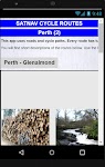
Satnav Cycle Routes – Perth(2) – Click to show
Satnav Cycle Routes – Perth(2)
Ian Lochhead
Perth - Glenalmond. 35 miles Perth - Crieff. 38 miles Perth - Milnathort. 38 miles Satnav Cycle Routes around Perth using cycle paths and roads. Every route has turn-by-turn navigation with voice in…
$0.99
0.0
0+ downloads
|
Maps & Navigation
0.0
$0.99
Ian Lochhead
0+ downloads
TRANSPORTATION
Satnav Cycle Routes – Perth(2)
Perth - Glenalmond. 35 miles Perth - Crieff. 38 miles Perth - Milnathort. 38 miles Satnav Cycle Routes around Perth us…
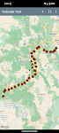
Thorsborne Trail
Jonathan Ide
This is the only app for hikers either walking or thinking of walking the iconic Thorsborne Trail on World Heritage listed Hinchinbrook Island in Far North Queensland, Australia. It is the perfect el…
$4.49
0.0
1,000+ downloads
|
Maps & Navigation
0.0
$4.49
Jonathan Ide
1,000+ downloads
TRANSPORTATION
Thorsborne Trail
This is the only app for hikers either walking or thinking of walking the iconic Thorsborne Trail on World Heritage lis…
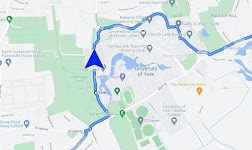
Satnav Cycle Routes – York – Click to show
Satnav Cycle Routes – York
Ian Lochhead
3 Satnav Cycle Routes around York. 1. Around York - 19.5 miles 2. York to Stamford Bridge - 28.3 miles 3. York to Tadcaster - 21.3 miles Satnav Cycle Routes around York using cycle paths and roads. …
$0.99
0.0
0+ downloads
|
Maps & Navigation
0.0
$0.99
Ian Lochhead
0+ downloads
TRANSPORTATION
Satnav Cycle Routes – York
3 Satnav Cycle Routes around York. 1. Around York - 19.5 miles 2. York to Stamford Bridge - 28.3 miles 3. York to Tadca…
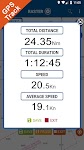
GPS Compass Navigation Pro
Darko Belev
From now on your hiking, hill climbing and walking will be easy. Use compass, navigation, record your routes, save your locations, take photos with GPS tag... and much more. COMPASS - Magnetic and t…
$4.99
0.0
50+ downloads
|
Maps & Navigation
0.0
$4.99
Darko Belev
50+ downloads
TRANSPORTATION
GPS Compass Navigation Pro
From now on your hiking, hill climbing and walking will be easy. Use compass, navigation, record your routes, save your…
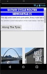
Satnav Cycle Routes-Newcastle1 – Click to show
Satnav Cycle Routes-Newcastle1
Ian Lochhead
1. Along the Tyne - 15 miles 2. Newcastle to Gateshead - 23.5 miles 3. Newcastle to Sunderland - 39 miles Satnav Cycle Routes around Newcastle using cycle paths and roads. Every route has turn-by-tu…
$0.99
0.0
0+ downloads
|
Maps & Navigation
0.0
$0.99
Ian Lochhead
0+ downloads
TRANSPORTATION
Satnav Cycle Routes-Newcastle1
1. Along the Tyne - 15 miles 2. Newcastle to Gateshead - 23.5 miles 3. Newcastle to Sunderland - 39 miles Satnav Cycle…
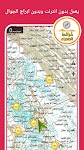
نافيتيل عربي - خرائط الصحراء
نافتيل عربي
تطبيق خرائط البر يوفر لك احدث وافضل الخرائط البرية لجميع الدول العربية تعمل على تطبيق نافتيل نوفره لك باللغة العربية وتعمل على الاقمار الصناعية بدون انترنت وبدون ابراج الجوال وفي وضع الطيران عن طريق…
$10.99
0.0
100+ downloads
|
Maps & Navigation
0.0
$10.99
نافتيل عربي
100+ downloads
TRANSPORTATION
نافيتيل عربي - خرائط الصحراء
تطبيق خرائط البر يوفر لك احدث وافضل الخرائط البرية لجميع الدول العربية تعمل على تطبيق نافتيل نوفره لك باللغة العربية و…
Isola del Giglio GPS Navigator – Click to show
Isola del Giglio GPS Navigator
FLYTOMAP INC
Flytomap is a valid and interesting alternative, Featured on the Deck Featured on Geomedia Worldwide Marine and Outdoor Maps available when connected, thanks to viewer.flytomap.com Worldwide Satelli…
$3.99
0.0
1+ downloads
|
Maps & Navigation
0.0
$3.99
FLYTOMAP INC
1+ downloads
TRANSPORTATION
Isola del Giglio GPS Navigator
Flytomap is a valid and interesting alternative, Featured on the Deck Featured on Geomedia Worldwide Marine and Outdoo…
Satnav CycleRoutes–Dunfermline – Click to show
Satnav CycleRoutes–Dunfermline
Ian Lochhead
Dunfermline - Kincardine. 28.6 miles Dunfermline - Limekilns. 14.4 miles Satnav Cycle Routes around Dunfermline using cycle paths and roads. Every route has turn-by-turn navigation with voice instru…
$0.99
0.0
0+ downloads
|
Maps & Navigation
0.0
$0.99
Ian Lochhead
0+ downloads
TRANSPORTATION
Satnav CycleRoutes–Dunfermline
Dunfermline - Kincardine. 28.6 miles Dunfermline - Limekilns. 14.4 miles Satnav Cycle Routes around Dunfermline using …
Transportes Andalucía PRO
Fran Caballero Software
AVAILABLE ON ENGLISH. Enhance your journeys across Andalusia (Andalucía, Spain) with our public transportation app. Instantly access updated schedules for buses, trains, metro, and boats acro…
$3.49
0.0
5+ downloads
|
Maps & Navigation
0.0
$3.49
Fran Caballero Software
5+ downloads
TRANSPORTATION
Transportes Andalucía PRO
AVAILABLE ON ENGLISH. Enhance your journeys across Andalusia (Andalucía, Spain) with our public transportation …
Old Hickory Lake GPS Charts – Click to show
Old Hickory Lake GPS Charts
FLYTOMAP INC
Flytomap is a valid and interesting alternative, Featured on the Deck Featured on Geomedia Worldwide Marine and Outdoor Maps available when connected, thanks to viewer.flytomap.com Worldwide Satelli…
$3.99
0.0
10+ downloads
|
Maps & Navigation
0.0
$3.99
FLYTOMAP INC
10+ downloads
TRANSPORTATION
Old Hickory Lake GPS Charts
Flytomap is a valid and interesting alternative, Featured on the Deck Featured on Geomedia Worldwide Marine and Outdoo…
Lake Hendricks IOWA GPS Charts – Click to show
Lake Hendricks IOWA GPS Charts
FLYTOMAP
Flytomap is a valid and interesting alternative, Benetti Yachts Featured on the Deck Featured on Geomedia Worldwide Marine and Outdoor Maps available when connected, thanks to viewer.flytomap.com Wor…
$3.49
0.0
0+ downloads
|
Maps & Navigation
0.0
$3.49
FLYTOMAP
0+ downloads
TRANSPORTATION
Lake Hendricks IOWA GPS Charts
Flytomap is a valid and interesting alternative, Benetti Yachts Featured on the Deck Featured on Geomedia Worldwide Mar…
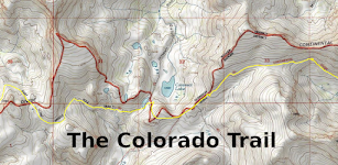
Colorado Trail
ColoradoSingleTrack
The Colorado Trail (#1776) is a collection of roads and trails managed by the United States Forest Service that generally follows the Continental Divide between Denver and Durango. The trail splits i…
$0.99
0.0
10+ downloads
|
Maps & Navigation
0.0
$0.99
ColoradoSingleTrack
10+ downloads
TRANSPORTATION
Colorado Trail
The Colorado Trail (#1776) is a collection of roads and trails managed by the United States Forest Service that general…
ViaBus +
SFR71
En ViaBus Facilitamos el trabajo a los profesionales de pasajeros por carretera. Además encuentras todo lo que en nuestro trabajo podemos necesitar. Buscar un Guía oficial de cualquier …
$16.99
0.0
50+ downloads
|
Maps & Navigation
0.0
$16.99
SFR71
50+ downloads
TRANSPORTATION
ViaBus +
En ViaBus Facilitamos el trabajo a los profesionales de pasajeros por carretera. Además encuentras todo lo que e…
Navigation Pro: Maps on Watch
Smartwatch Studios
Displays Google Navigation instructions from the phone on your Samsung watch. Great for driving, cycling and public transport. Features autostart with navigation, voice output, customizable vibration…
$2.99
4.7
1,000,000+ downloads
|
Maps & Navigation
4.7
$2.99
Smartwatch Studios
1,000,000+ downloads
TRANSPORTATION
Navigation Pro: Maps on Watch
Displays Google Navigation instructions from the phone on your Samsung watch. Great for driving, cycling and public tra…
United States
United Kingdom
Germany
Norway
Sweden
Australia
Netherlands
Italy
Denmark
Hong Kong
Brazil
France
Canada
Spain
Portugal
South Korea
Japan
Poland
Hungary
India
Finland
Thailand
Russia
General
Overall
Applications
Games
Join AppBrain
Join AppBrain to get app recommendations
Apps
Art & Design
Auto & Vehicles
Beauty
Books & Reference
Business
Comics
Communication
Dating
Education
Entertainment
Events
Finance
Food & Drink
Health & Fitness
House & Home
Libraries & Demo
Lifestyle
Maps & Navigation
Medical
Music & Audio
News & Magazines
Parenting
Personalization
Photography
Productivity
Shopping
Social
Sports
Tools
Travel & Local
Video Players & Editors
Weather
Games
Action
Adventure
Arcade
Board
Card
Casino
Casual
Educational
Music
Puzzle
Racing
Role Playing
Simulation
Sports Games
Strategy
Trivia
Word