
Rother: Hiking Tours & Maps
5.3
Bergverlag Rother GmbH
2.33
3 reviews
Free


About Rother: Hiking Tours & Maps
Rother: Hiking Tours & Maps is an app developed
by Bergverlag Rother GmbH.
The app has been available since May 2012.
It's top ranked.
It's rated 2.33 out of 5 stars, based on 3 ratings. The last update of the app was on January 30, 2025. Rother: Hiking Tours & Maps has a content rating "Everyone".
Rother: Hiking Tours & Maps has an download size of 59.47 MB and the latest version available is 5.3. Rother: Hiking Tours & Maps is FREE to download.
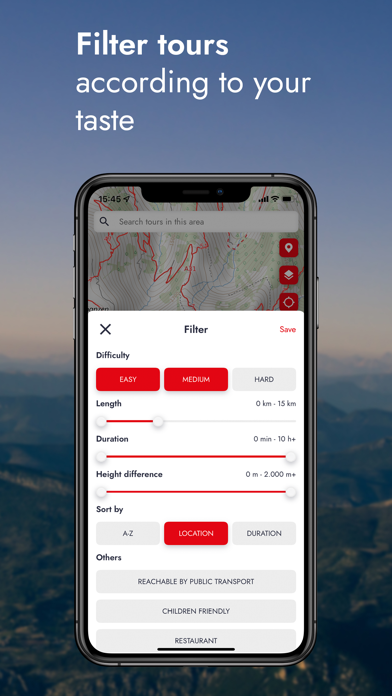
Description
More data about Rother: Hiking Tours & Maps
| Price | Free to download |
| Rating | 2.33 based on 3 ratings |
| Ranking | Top ranked |
| Version | 5.3 |
| App download size | 59.5 MB |
| Suitable for | Everyone |
Alternatives for the Rother: Hiking Tours & Maps app


 DJH Youth Hostels in Germany
Deutsches Jugendherbergswerk Hauptverband fuer Jugendwandern und Jugendherbergen e.V
Free


Changelog
No changelog data
Developer information for Bergverlag Rother GmbH
Bergverlag Rother GmbH
N/A
Share
Comments on Rother: Hiking Tours & Maps for iOS
We don't have enough comments to show example comments. Please check back later.
App Store Rankings
Top rankings
| Rank | Country | Category | List |
|---|---|---|---|
| 17 | Germany | Travel | Top Grossing |
| 50 | France | Travel | Top Grossing |
| 26 | Austria | Travel | Top Grossing |
| 38 | Switzerland | Travel | Top Grossing |
| 49 | Denmark | Travel | Top Grossing |
Ranking history in Germany
AppBrain offers valuable information about your app and those of your competitors. Join AppBrain for free and claim this app to view more ranking data, view history etc.
I'm the developer of this app
Technologies used by Rother: Hiking Tours & Maps
Back to top